Wastewater treatment plant – orthophotos for flow analysis
By olah
23. February 2023
Project number: 9.902.60006
Involved cooperation partners:
Holding Graz
FH JOANNEUM | University of Applied Sciences
AIRlabs Austria
Project Description/Methods:
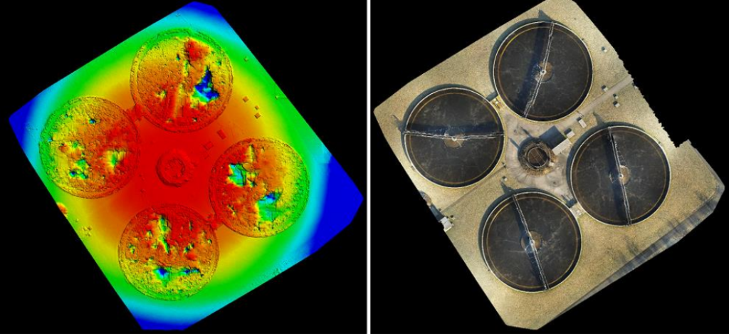
The project involves flying over the secondary settling tanks with an “open” category drone (in the control zone of Graz Airport) and taking orthophotos of all 4 settling tanks in order to test the applicability of such images in the optical range for visualising the flow, especially dead water areas and desired circulations. The particular challenge is that the flow analysis is carried out without the additive admixture of additional particles (e.g. styrofoam balls, paints) and is to be recorded solely by photo-optical sensor technology in the visible range. In addition, this is to be done both on the hardware and software side with off-the-shelf solutions and their suitability as well as any gaps in feasibility are to be identified.
The aircraft used is the Parrot Anafi Thermal (see Figure 1), which is not only adequately equipped in terms of sensors due to the built-in optical camera, but can also be classified in category A2 of the EU-wide UAS regulations due to its low weight, thus allowing such flights to be carried out at a very low threshold. In addition, the above-mentioned system – in contrast to comparable devices from other manufacturers in terms of weight – has the option of using defined applications from third-party providers, which are specialised in surveying and image processing tasks in this specific use case.
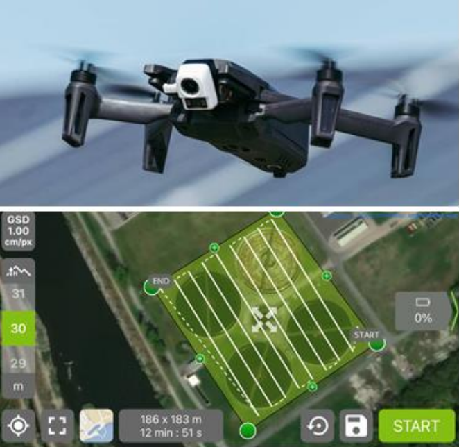
By means of a mobile application from the manufacturer “Pix4D”, a grid to be flown along the 4 settling tanks on the grounds of the wastewater treatment plant in Gössendorf was defined (see Figure 1), which the UAV flew over independently and took the necessary individual images for the calculation of the total mosaic, whereby another off-the-shelf software solution was used for this procedure. As the wastewater treatment plant is located within the control zone of Graz Airport (CTR LOWG), the flights were always registered with the responsible air traffic controller in compliance with the law immediately before they took off.
Results/Dissemination:
The utilising authorities confirmed the practicability of the images for the desired analysis objectives and the associated innovative advance already after the first flight in May 2022, which is why validation flights were also carried out at other seasons. It was shown that the hardware and software solutions used completely fulfilled the requirements of the project at hand and that practical results could be achieved with methods that could be carried out very efficiently and at a very low cost (airborne image generation, software-supported orthophoto calculation).